Public Auction
3,000 +/- Acres of Land
FOR SALE
North Ambregris Caye, BelizeDistrict
BELIZE, CENTRAL AMERICA
Auction Notice
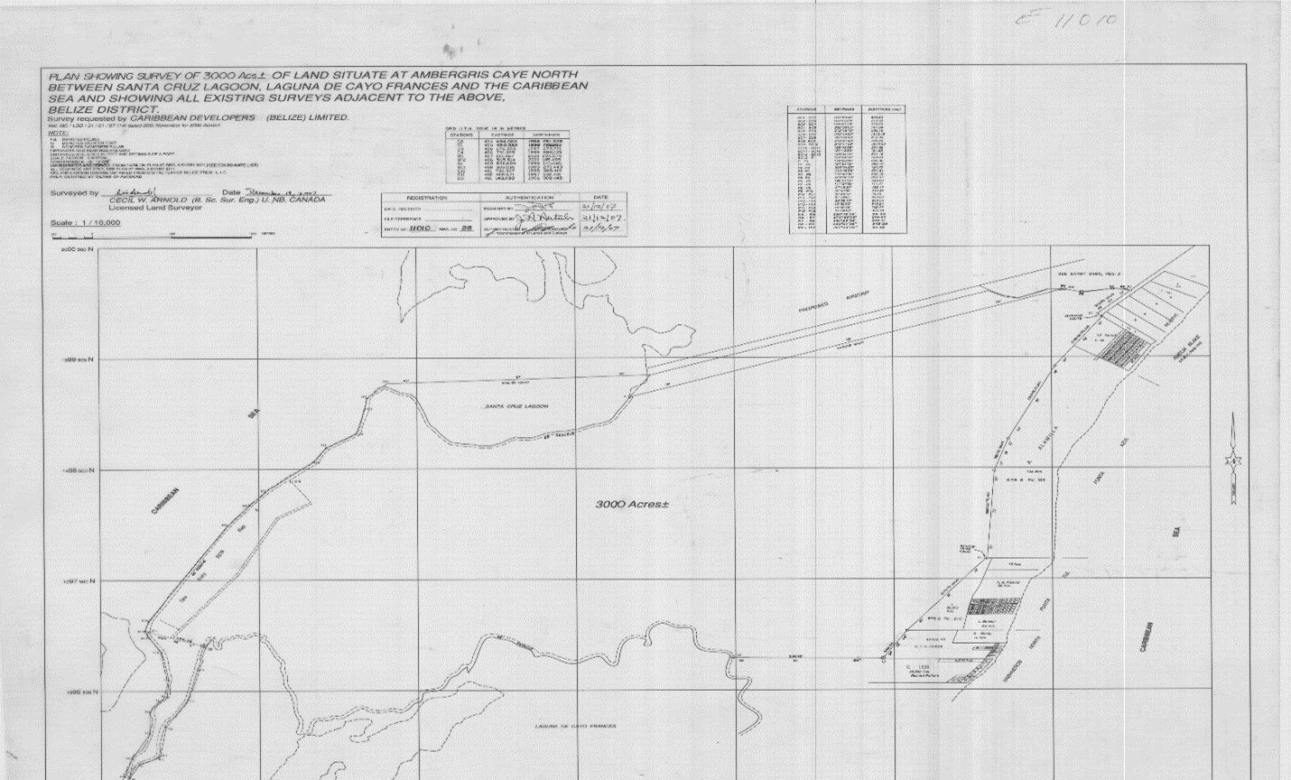
By Order of the Chargee, the Industrial Bank of Korea and Rodwell R.A.Williams, the Receiver of Caribbean Developers (Belize) Limited, Licensed Auctioneer Kareem Elrington will sell on Saturday, the 30th day of May, 2026 at 10:00 a.m. at No. 84 Albert Street, Belize City, Belize (parking lot of Barrow & Williams LLP), the property described below being Parcel 10409 Block 7 San Pedro Registration Section, comprising about 3,000 acres of land situate about 13 miles North of San Pedro Town, Ambergris Caye, Belize District:
For further particulars, visit: www.barrowandwilliams.com [Public Auction]
Written pre-bids may be sent to Rodwell R. A. Williams, Receiver at No. 84 Albert Street, Belize City, Belize District, Belize, Email: [email protected] no later than 48 hours prior to the aforesaid public auction date of sale.
Dated the 5th day of May, 2026.
BARROW & WILLIAMS LLP
Per: RODWELL R. A. WILLIAMS, S.C., C.B.E.
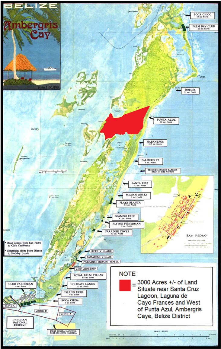
Location
LOCATION OF THE PROPERTY ON AMBERGRIS CAYE:
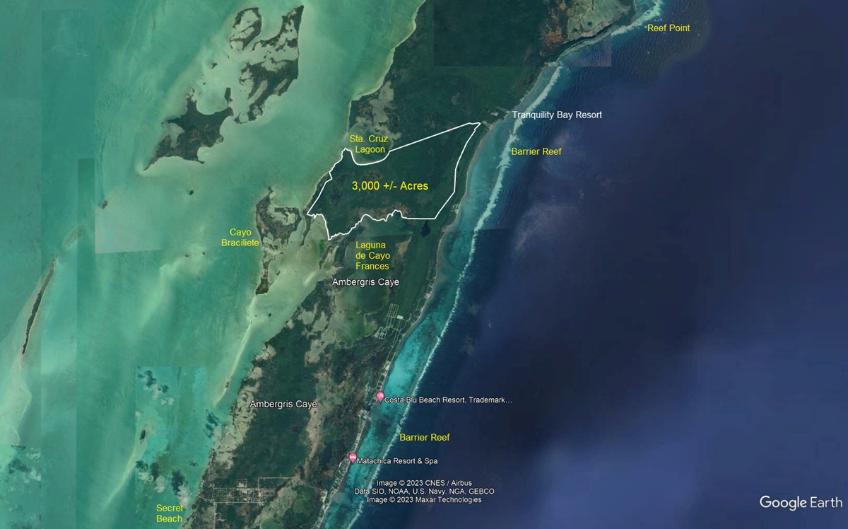
AERIAL IMAGERY (Courtesy of Google Earth)
NOTE: The 3,000+/- acres of land is shown bordered in white lines. Other landmarks on or near Ambergris Caye have been labelled hereon.
Description of Property
The subject property is located approximately 15 miles North of the southernmost tip of the Yucatan Peninsula on Ambergris Caye, Belize District. The only municipality on the island is San Pedro Town, an internationally recognized tourist destination.
The property (when scaled in a straight line) is located approximately 10 miles in a north-easterly direction from the Barry Bowen Bridge, the only bridge on the island which spans the Rio de San Pedro (San Pedro River) in the township. The property is accessible by way of the existing road network on North Ambergris Caye and by way of boat travel which takes approximately 35 – 45 minutes from the town center in San Pedro Town.
The property is situate South of the Laguna de Santa Cruz, West of the Punta Azul Cocal (a property that is located along the eastern coastline of Ambergris Caye) and North of the Laguna de Cayo Frances. The western boundary of the property fronts on the Sea.
Geographically, the position of the property is fixed within the northwest quadrant of the Universal Transverse Mercator Zone 16 and the center of the property bears the coordinates 1998 500 metres Northings and 404 000 metres Eastings and in latitude and longitude based on scaled coordinates courtesy of Google Earth are 18° 04’ 15.27” N and 87° 54’ 35.06” W.
This unspoiled, untouched, beautiful and natural property comprises of approximately 3,000 acres of land making it ideal to support mixed-use development. It comprises of a sandy beach ridge, mangrove and littoral forest, marshlands, wetlands and open water and lowland broad-leaved dry forest that can support agriculture.
The size of this property can facilitate a diversified residential, commercial, amenity-based tourism development, light industrial development and agricultural development.
There are many attractions to this property.
The western boundary of the property is the coastline that sits along the beautiful turquoise waters of the Caribbean Sea. The impact of the sargasso grass along the eastern coastline of Ambergris Caye has caused the west side of island to bloom especially with the growing developments around the Secret Beach and Caribbean Coves area.
The property can support single family residences, multi-family residences, resorts, hotels, villas, casino(s), golf course(s), restaurants, bars, pools, commercial activity, dive shops and other support amenities and services.
The property supports agricultural development. Presently, all produce is shipped to Ambergris Caye making it very expensive. A farm on the property that produces local vegetables and greenery can provide less costly vegetables to the residents and visitors to the island resulting in a more healthy lifestyle for all.
The Maya archaeological site located on the property is often referred to as either “Punta Limon Site” or “Santa Cruz Site”. According to research, it is estimated that over 22,000 Maya inhabited Ambergris Caye approximately 2000 years ago and produced salt for trading. The site clearly stands out from the surrounding mangrove swamp because of its distinctive vegetation and the dark soils.
The flora on the property consists of white, red, black and buttonwood mangroves. The littoral forest includes black poison wood, red and white gumbo limbo trees, sapodilla, wild sea grape, coco plum, coconut, saltwater palmettos and a diverse array of other plants, trees and shrubbery.
The property abounds with nature and there are terrestrial wildlife that roam the land. The animals include white-tailed deers, warries, pecarries, racoons, squirrels and jaguars. There are many species of birds that include vireos, flycatchers, kiskadees, chachalacas, hummingbirds, hawks and woodpeckers. These attractions make the property ideal for nature trails and horseback riding.
The Tranquility Bay Resort that is located along the eastern coastline of North Ambergris Caye is within close proximity of the property.
There is an abandoned airstrip that is located just north of the property that can be brought back into commission as an aerodrome.
Additional Information
Property Summary Report
Click above to download
Photo Gallery
Click above to download